
Transit-Oriented Development in Doha: The Case of the Al Sadd Neighborhood and Hamad Hospital Metro Station
by
 , ,
, ,
Sara Nafi
1, 
Raffaello Furlan
1,* ,
,
Michael Grosvald
2,
Rashid Al-Matwi
1 and
Khalida Lifam Marthya
1 1
Department of Architecture and Urban Planning, Qatar University, Doha 3263, Qatar
2
Department of English Literature and Linguistics, Qatar University, Doha 2713, Qatar
*
Author to whom correspondence should be addressed.
Designs 2021, 5(4), 61; https://doi.org/10.3390/designs5040061
Submission received: 6 April 2021
/
Revised: 8 September 2021
/
Accepted: 16 September 2021
/
Published: 29 September 2021
(This article belongs to the Special Issue Sustainable Architecture Design)
Abstract
:Over the last two decades, transit-oriented development (TOD) has been widely implemented as an integrated strategy to enhance urban livability. Doha, the capital of the State of Qatar, has faced urban challenges such as excessive reliance on private vehicles, absence of a well-established public transportation system, and issues with integration of last-mile connectivity. This research study explores Al Sadd, a mixed-use neighborhood in Doha, in order to investigate key factors to be addressed for enhancing urban livability within this neighborhood. These factors were analyzed through a combination of qualitative and quantitative methods incorporating: (1) a literature review focusing on sustainability, smart growth, and transit-oriented development; (2) data collection and analysis utilizing oral and visual data from the Qatari Ministry of Municipality and Environment (MME), Qatar Rail, and private engineering and consulting companies; and (3) analytical and applied study through site analysis, observation, photographs, and field notes. A regeneration master plan for the study area proposes the creation of avenues for urban interaction through the introduction of community open spaces, pedestrian-friendly streets, and other measures promoting city compactness. The outcome of this research study illustrates how the enactment of a TOD model can lead to smart growth and eco-friendly urban living by emphasizing TOD principles which promote a pedestrian-oriented neighborhood.
1. Introduction
A growing number of communities have embraced transit-oriented development (TOD) as a means of improving the urban fabric of cities. TOD has served as an integrated strategy for merging land-use and transportation networks, for enhancing compact urban forms, and for promoting public transport use by reducing the use of private vehicles [1,2].
The urban form of Doha, the capital of Qatar, has created significant challenges for city planners due in part to fragmented land use and lack of integration of transport services, facilities, and infrastructure. The city is characterized by a high dependence on private vehicles and insufficient public transportation, resulting in a great deal of traffic congestion [3]. At the current pace of development, Doha and its environs will almost certainly be obliged to plan TODs to improve the living conditions of its urban areas. The implementation of the Doha metro, which will include several dozen stations spread across four primary lines, provides an opportunity to put into practice a wide-ranging strategy promoting the urban regeneration of the city’s main transit villages [4].
Cities are enlivened by their transport systems and as a planning tool, TOD aims to increase the usage of public transport around transit nodes. The TOD model integrates land-use and transport systems, thus forming sustainable and pedestrian-friendly neighborhoods. One of the objectives of Qatar National Vision 2030 is to foster sustainable growth. TOD, in encouraging people to use metro systems and other forms of public transit for long trips and non-motorized means of transport such as cycling for short trips, is an important aspect of such growth [5].
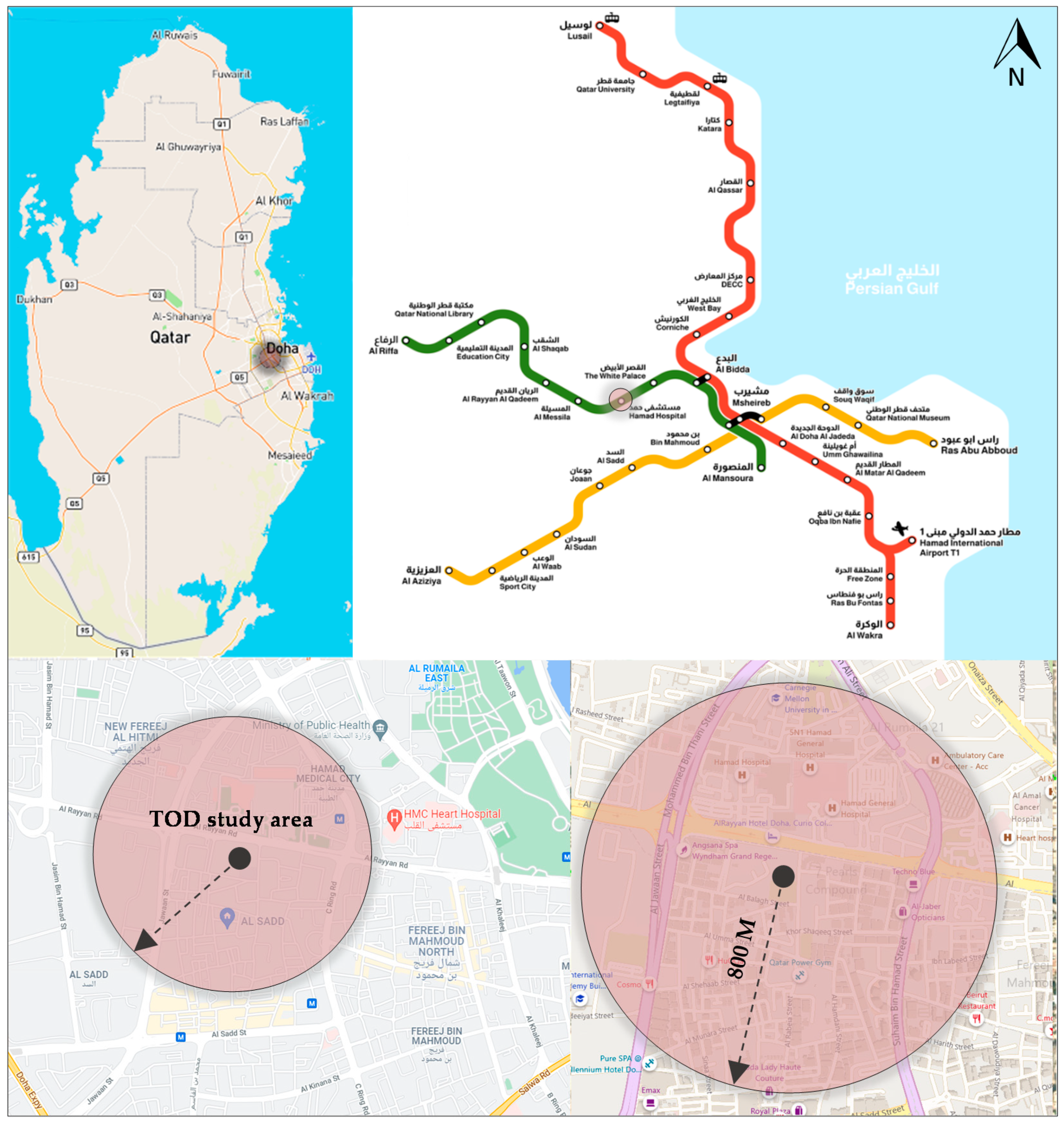
The aim of this paper is to study the implementation of the TOD model in the Al Sadd neighborhood, a mixed-use area in central Doha. The study area comprises a zone of 800 m radius centered around the Hamad Hospital metro station. Both qualitative and quantitative methodologies were employed in the study. Methods include theoretical review of several topics related to the study, site observation, and data collection from relevant authorities and consulting companies. More specifically: (1) the literature review addresses the topics of sustainability, smart growth, and transit-oriented development; (2) the data collection and analysis focus on oral and visual data from the Ministry of Municipality and Environment (MME), Qatar Rail, and private engineering and consulting companies; and (3) the analytical and applied study incorporates site observation and analysis, photographs, and field notes. The paper proposes an approach to improving the urban fabric of the study area by introducing a set of TOD-based design recommendations and guidelines.
2. Background
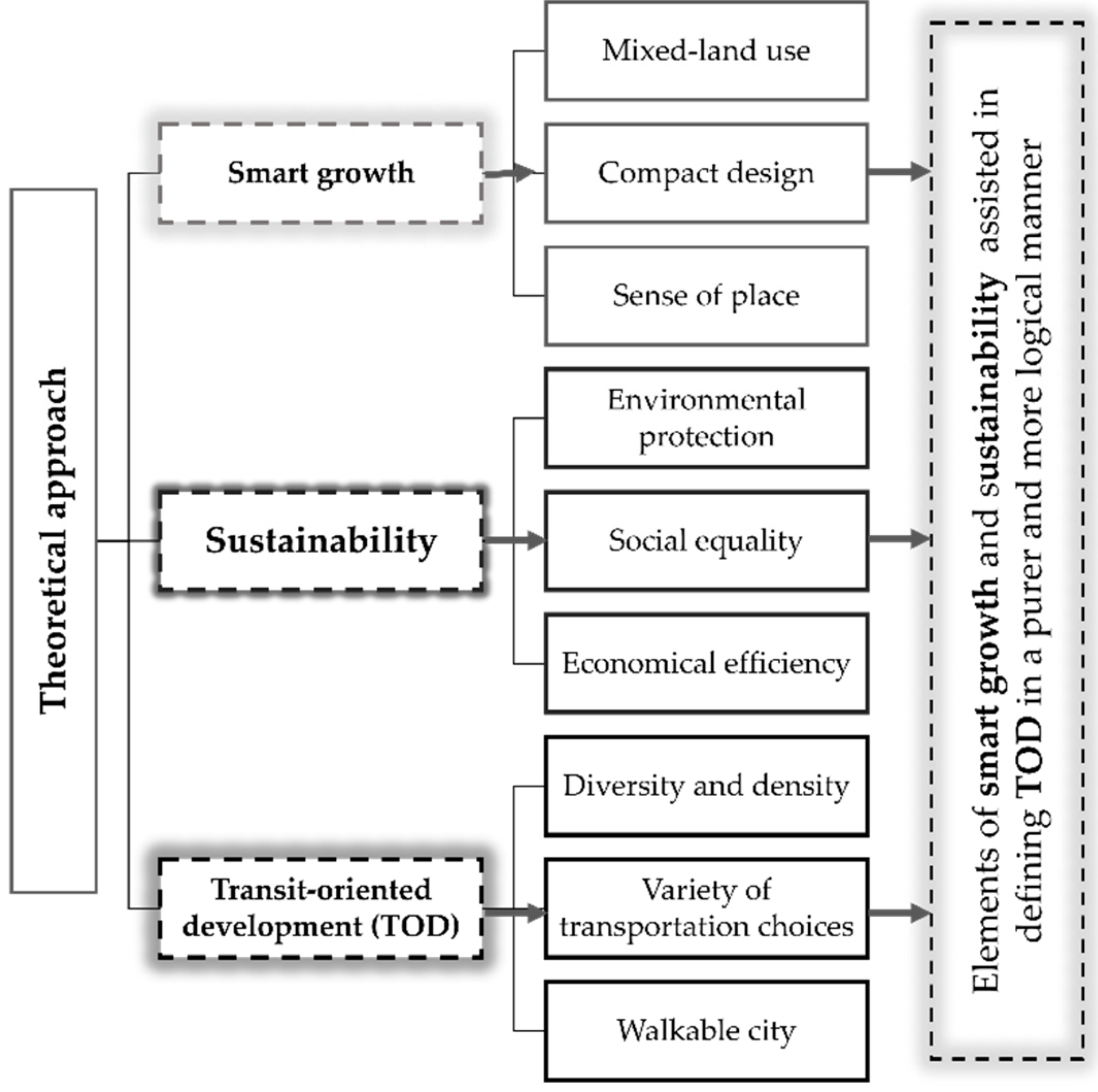
2.1. Smart Growth, Sustainability and Transit-Oriented Development (TOD)
Smart growth is a development model that emphasizes the creation of walkable dense urban centers by diversifying land use, housing type, and transit options. The principles of smart growth in a city’s planning include the promotion of desirable land use indicators such as diversity, mixed-use and enhanced open space, and unique neighborhoods with a clear sense of place. Users’ walking and transportation experience is enhanced by communities featuring connectivity, walkability, compactness, and density. Smart growth incorporates the vision of imaginative developers, planners and experts concerned with integrating innovative forms of development [6].
Transportation and urban planning specialists typically consider smart growth to be a response to ongoing and increasing needs, aimed at addressing environmental concerns and enhancing the quality of transport facilities. The key idea is that city planning and land development designs that are informed by transportation investments and policies are a strong predictor of successful outcomes in terms of user satisfaction and travel behaviors. This connection underlies the attractiveness of smart growth communities, which enhance residents’ ability to reach their destinations on foot and by bringing them closer to those destinations. Consequently, smart growth—along with other cohesive transportation land use schemes—should be promoted as a way of creating walkable environments which favor healthy physical activity. Smart growth neighborhoods demonstrate efficient growth patterns incorporating pedestrian-friendly designs, land use diversities, and higher densities, collectively aimed at reducing the use of personal vehicles for short trips [7]. Furthermore, smart growth is frequently described by scholars and experts in terms of transportation land-use coordination (TLC), which for years has been a leading approach favored by urban designers, planners, and engineers. A number of studies have drawn a connection between smart growth in transit-oriented developments (TOD) and positive outcomes related to livability, sustainability, well-being, and fairness [7,8].
TOD has been recognized as an important tool for cities aiming to achieve smart growth and sustainable planning. In general, TOD for a given city involves a transport network covering the entirety of that city. As a result, catchment areas are generally taken into account at the city level rather than at the level of an individual transport station. This requires a comprehensive understanding of land-use planning and the factors that feed into it. Land-use changes likely to affect or be affected by local environmental factors should be carefully considered [9].
Today, TOD is a well-established urban planning model aimed at enhancing the quality of accommodation, promoting affordability, and diversifying public spaces. When TOD is planned and implemented in an effective manner, it can help propel progress toward the creation of sustainable and vital cities. TOD also enhances wealth creation, helps create economic and other opportunities for residents, and allows communities to respond more flexibly to potential disruptive events such as pandemics. TOD helps minimize air pollution and improve affordability and sustainability by promoting the diversity of neighborhoods and the proximity and compactness of amenities close to public transportation [10]. TOD planning is vital in Qatar for the promotion of more varied modes of mobility, allowing better access for cyclists and pedestrians in addition to automobile users. Implemented properly, this can lead to an increase in the percentage of public transit users and a reduction in kilometers travelled in personal vehicles [11].
A TOD design strategy is also valuable for increasing revenue and reducing driving costs, as well as leading to reduced energy use and air pollution. It also helps to conserve land and open spaces, provide affordable housing, increase economic development, and reduce infrastructure spending [12].
2.2. The Influence of TOD
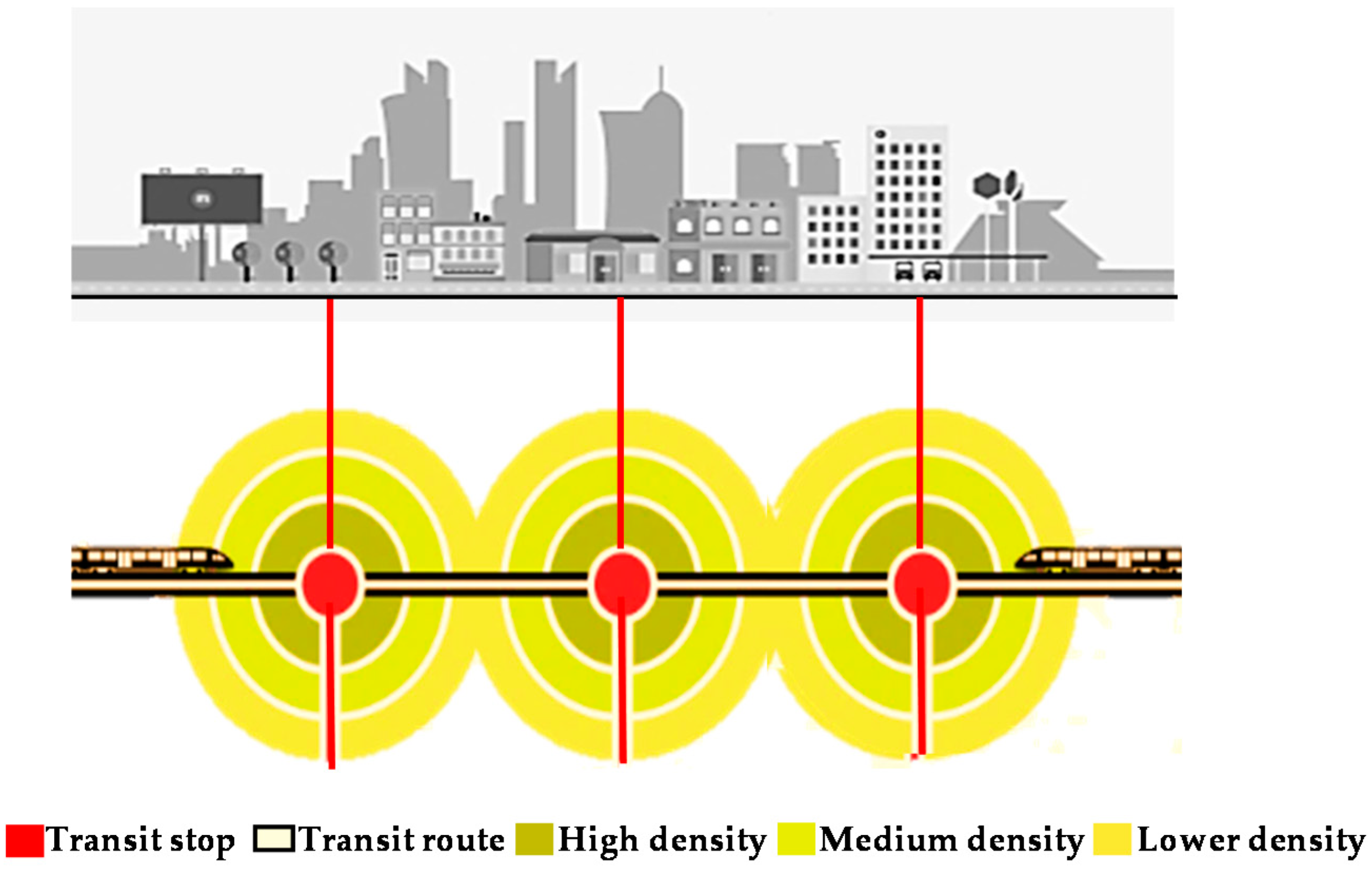
The TOD concept has had a massive impact in the transportation and urban planning literature. Although the definition of TOD can vary somewhat, Peter Calthorpe, the leader of the New Urbanism movement, describes a TOD as “a mixed-use community located within 2000 feet (or 10 min) of a central shopping area and a transit stop. TOD combines retail, residences, offices, public and open spaces in a pedestrian environment, allowing employees and residents to travel by public transportation, walking, cycling or driving” [12]. This measure of a walkable distance of a half-mile (roughly 800 m) is also consistent with the Western Australian Planning Commission’s (WAPC’s) 1997 Livable Neighborhoods Community Design Code and has been used extensively in other studies [13,14]. The rationale behind the 800 m walkable catchment radius is that any distance greater than 800 m would mean a “formal destination” for which people are more likely to use transport means other than walking. Calthorpe draws a distinction between a “TOD district” (located next to local bus lines which feed railway lines) and an “urban TOD” (located directly adjacent to a railway line). As initially conceived, various types of TOD were intended mainly at urbanizing suburban developments. As shown in Figure 1, Calthorpe conceived urban TODs as being focused more on employment centers than on housing-based neighborhoods [15].
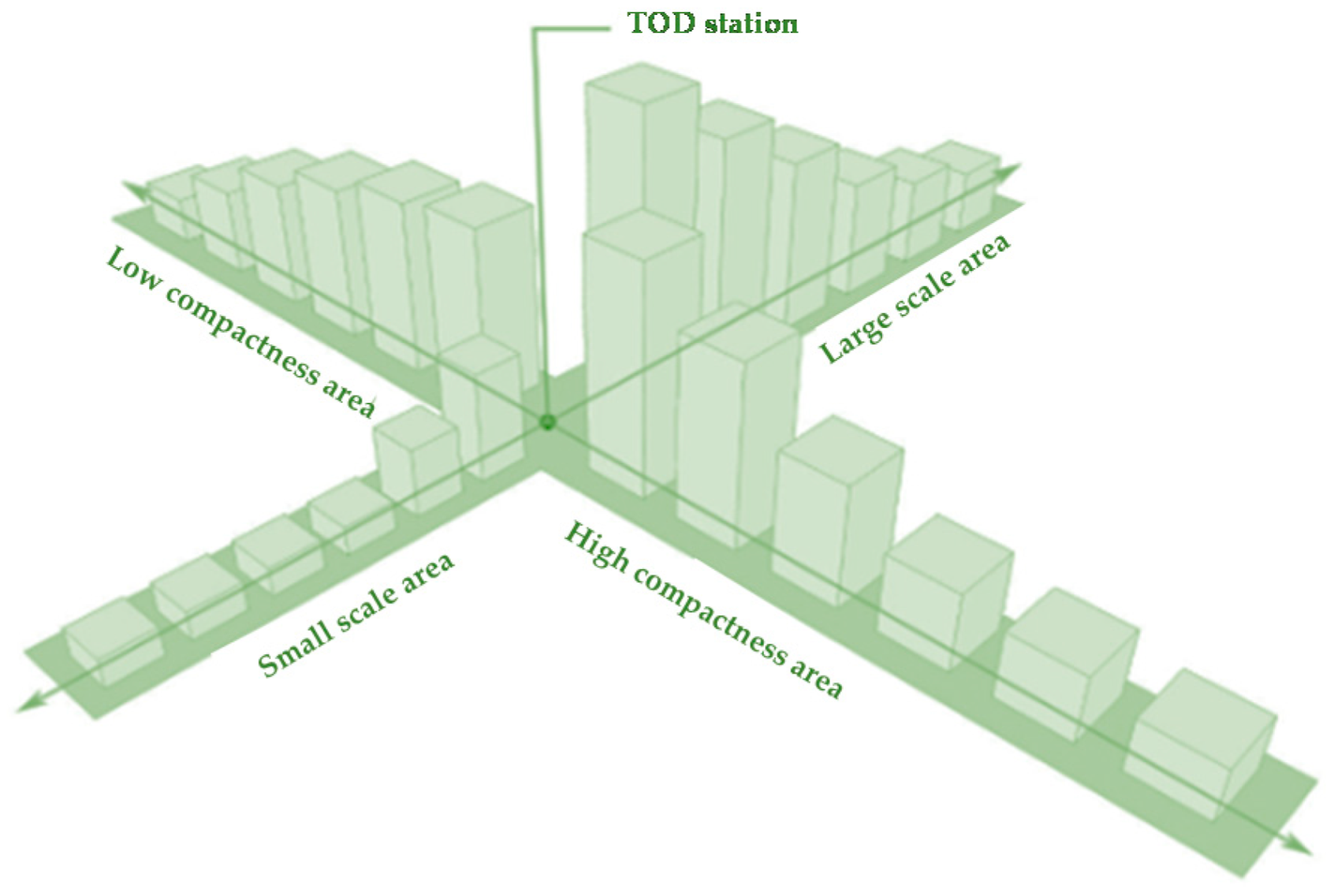
TOD promotes high-quality urban development with a mixed land use of residential, recreational, commercial and employment opportunities, planned in a pedestrian-oriented approach considering an appropriate scale for pedestrians without excluding the automobile. Proximity to transit stations can be assured by a compact city design. This allows riders to reach their destinations more easily, thus promoting enhanced ridership by making transit more accessible. TOD can mean redevelopment of an existing area, or the construction of one or more new buildings whose orientation and design accelerate the use of sustainable and convenient modes of transportation, including active transportation and public transit [16,17,18]. Figure 2 illustrates a TOD compact node concept.
The US state of Florida views TODs as “designated areas of mixed-use character, compact, moderate to high density developments, interconnected with other land uses, pedestrian and bicycle friendly, and planned to sustain a frequent transit service operating separately or collectively” [19]. TODs mix residential, commercial, office, retail, public uses, and open space within a walkable city, making it easy for workers and residents to move about by means of walking, cycling, or use of public transit [20,21].
All definitions seem to converge on a common vision in which a well-implemented TOD supports a given district’s transport system and enhances users’ economic prospects. These benefits derive from a multitude of factors, especially the development of mixed-use facilities that are easily accessible within a compact area, addressing uses’ needs and permitting healthy and useful activities around the clock [22].
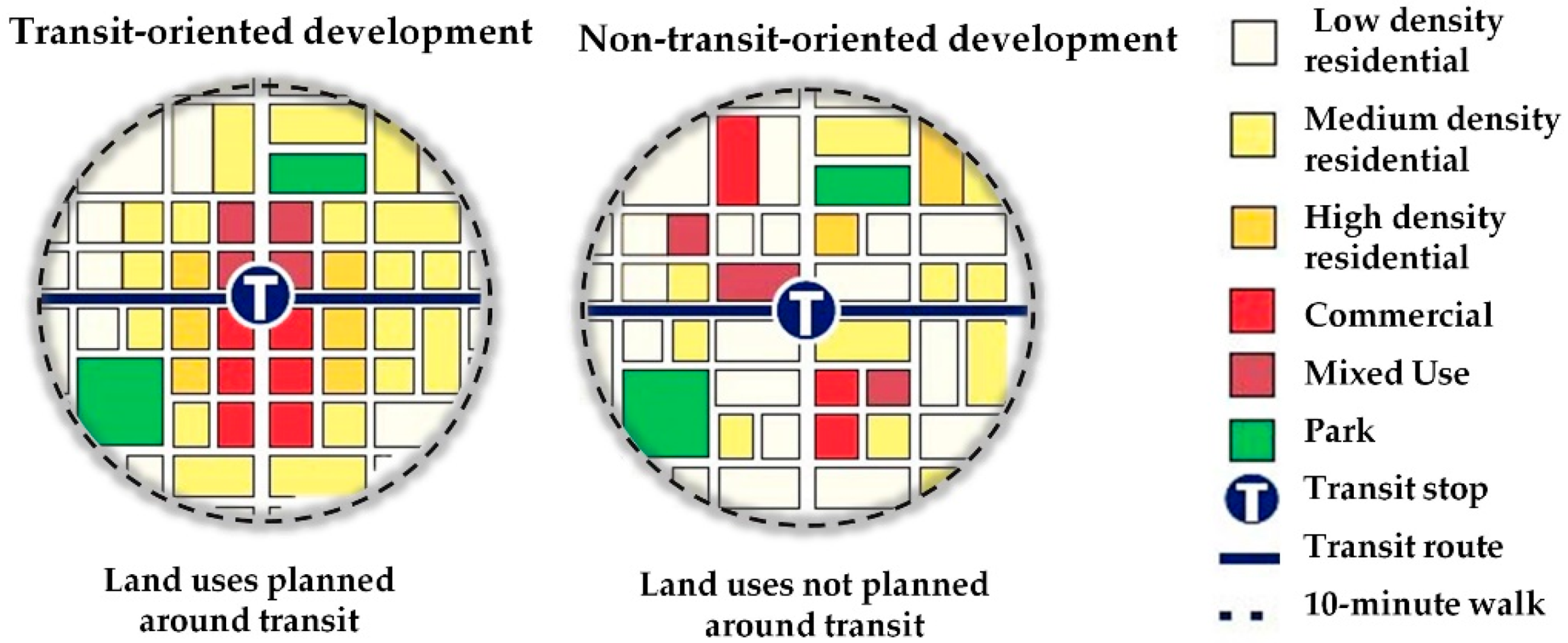
A set of TOD guidelines must consider not only transportation but also development and urban form. It aims at creating a compact, high-quality, mixed-form development which is pedestrian-friendly and accommodates efficient mass transport options. It is not straightforward to introduce a new form of development into a booming metropolitan area which already has a high density of development and a well-established transit system. However, for a major city, the development of transit systems prior to or along with the creation of the urban fabric can prove beneficial in later development plans; see Figure 3 [23].
Transit-oriented development has also been defined by [24] as “Concentrated mix of moderately dense and pedestrian friendly development around transit stations to promote transit riding, increased walk and cycle travel and other alternatives to use of private cars” A given neighborhood with a radius on the order of 400 m should incorporate cycling and pedestrian networks, with tram and/or bus stops at the edges. Neighborhoods whose radius is closer to 800 m should be accessible via tram, metro routes and/or bus stops at the periphery of the neighborhood [25]. These ideas are illustrated in Figure 4.
In research concerning TOD, land-use characteristics are commonly described in terms of design, variety and density [26]. In numerous growth policies, a high degree of diversity is supported throughout a given area, while density tends to change according to distance from the area’s transport station areas. Generally, density falls at greater such distances, but as the reputation (and perceived attractiveness) of a TOD location grows, the density of the area as a whole will also tend to increase [27].
2.3. TOD in Qatar: Hamad Station in Al Sadd
The State of Qatar has undergone rapid economic and urban development in recent times, particularly during the past two decades. The economy has transformed from one based on fishing and pearling to one based on energy, following the large-scale exploitation of oil and natural gas starting in the late 1930s [28]. Doha, the country’s capital, is now an internationally prominent city due to its hosting of unique international events such as the upcoming FIFA 2022 World Cup [29,30]. Along with globalization, broad infrastructure development has altered the city, with many traditional residential structures being replaced with modern buildings. As part of this process, the Central Business District of Doha has been established and commercial buildings have been built all over the city [31]. As an action plan for managing sustainable urban development at the national level, the Qatar National Development Framework (QNDF) was launched by the country’s authorities, and the construction of the Doha metro began in 2013 [32]. The QNDF highlights the importance of linking the Doha metro system with city growth through TODs [33]. The Doha metro network is designed to create transit areas in the city’s main cores, supported by ‘Light Rail Train’ (LRT) and ‘Bus Rapid Transit’ (BRT) systems, in order to ensure an efficient origin-to-destination experience for users. This will promote the utilization of public transportation and help achieve the sustainable development goals of Qatar National Vision 2030 [34].
Doha’s metro network connects the Doha Port, Hamad International Airport, the city’s main urban area, and all major stadium sites. The metro network will ultimately contain four lines—the Red, Green, Gold, and Blue lines—having a total length of 300 km, serving 100 stations, and operating underground, ground-level, and above-ground railways. The Red Line, also known as the Coast Line, runs for 40 km from Al Wakra in the south to Lusail in the north. The line connects Hamad International Airport to the city center. It covers 18 active stations, the most important of which include Qatar University, Katara, and West Bay. This line contains interchange stations between the tram and metro at the Lusail QNB and Legtaifiya stations [35], and also includes stations connecting to the Green Line. The Green Line, also known as the Education Line, runs 22 km east to west from Al Riffa to Al Mansoura. The line contains 11 stations with notable stops including Msheireb, Hamad Hospital, Qatar National Library, and Education City [36]. The Gold line, also called the Historic Line, runs 14 km from Al Aziziya to Ras Bu Aboud with 11 stations along the route, including stops at Souq Waqif, Qatar National Museum, Sport City, and Al Aziziya. Finally, the Blue Line (“City Line”) under-construction will link the West Bay and Airport City North areas along the main C-Ring Road, following a 7.5-km-long semi-circular route [37].
Qatar National Master Plan (QNDF) 2032 creates a framework containing short- and long-term objectives for the nation’s urban development. In accordance with the plan, all mega-projects should be completed by 2026, including those involving the public transportation system and infrastructure works, such as the Doha metro, light rail system, major highways, and national railway system [38]. The QNDF 2032 spatial approach envisions a network of urban areas made mutually accessible via the Doha metro, including Airport City, the West Bay area, and the government district in the city center, with other compact, transit-oriented metropolitan and city centers linked through transit corridors [39].
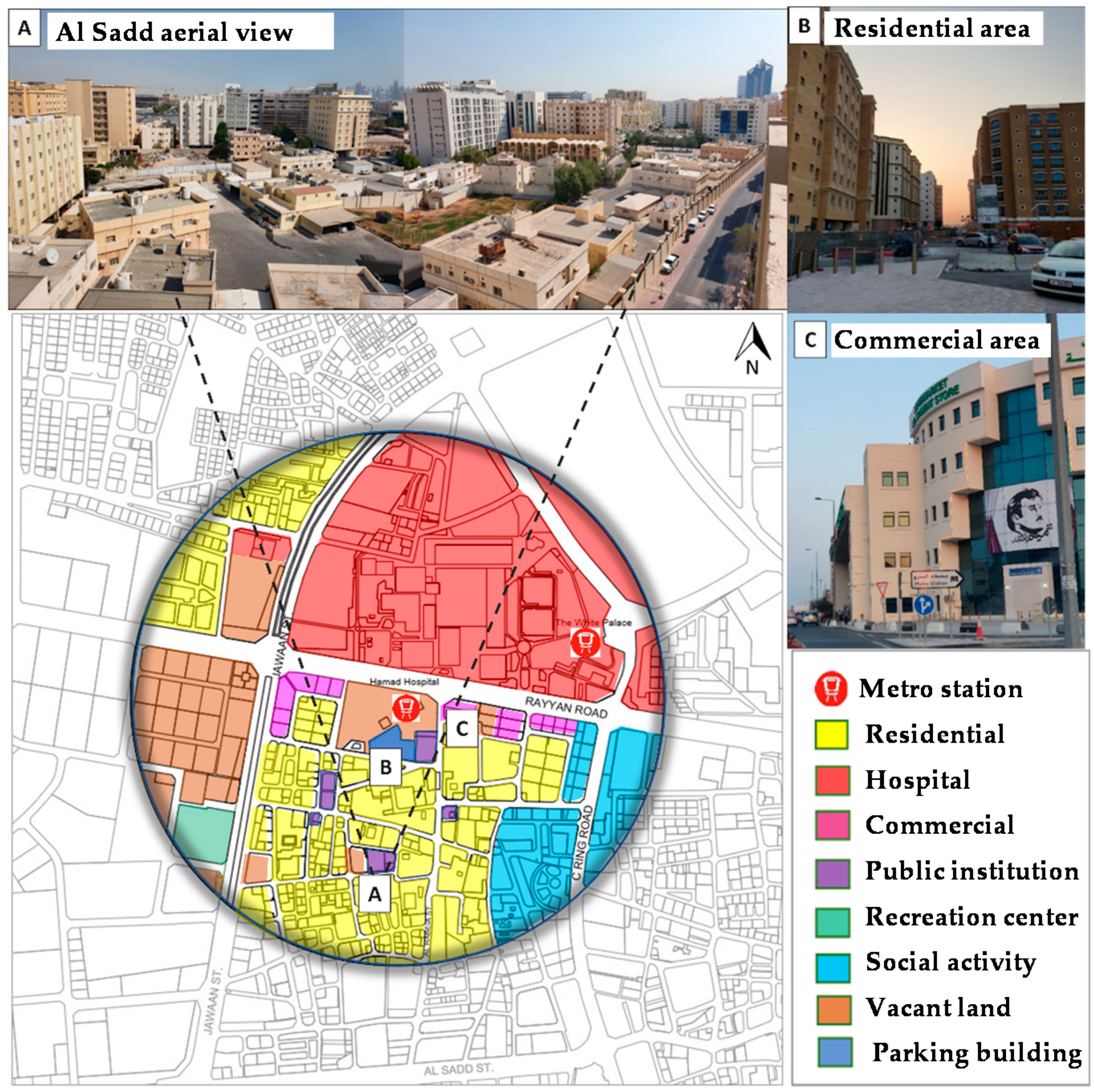
The study area for the present research project is illustrated in Figure 5. As shown in the figure, Hamad Hospital metro station is located in Doha’s Al Sadd neighborhood (Zone 38). The station lies adjacent to Al Rayyan Road, between Mohammad Bin Thani Street to the west and Ahmed Bin Ali Street to the east. Al Rayyan Road provides the primary frontage for this metro station, which serves the surrounding area. This high-density neighborhood includes buildings of up to eight stories in height and consists of residential areas, commercial buildings, and a medical complex called Hamad Medical City. There is also room for potential future development in this area. Analysis of aerial imagery shows that the inner fabric of the Al Sadd area follows a consistent grid pattern following the land classifications established by the planning municipalities and the government.
The Hamad Hospital metro station is classified as a “node center station” under the Qatar National Master Plan. One entrance is located on the southern side of Al Rayyan Road and includes bicycle storage and waiting areas for buses. A second station entrance is a corner entryway accessing Al Balagh Street and a smaller road, and also includes a bicycle storage area. This location is more prominent and more easily accessible, and thus is better able to serve the area around the metro station, which includes high-density residential zones. In addition, a potential future station entrance on Al Rabeia Road will provide access to a street that is expected to come into use in the future, providing a north–south linkage from Al Rayyan Road to Al Sadd Street and to the central area of the Al Sadd neighborhood [39].
3. The Research Design
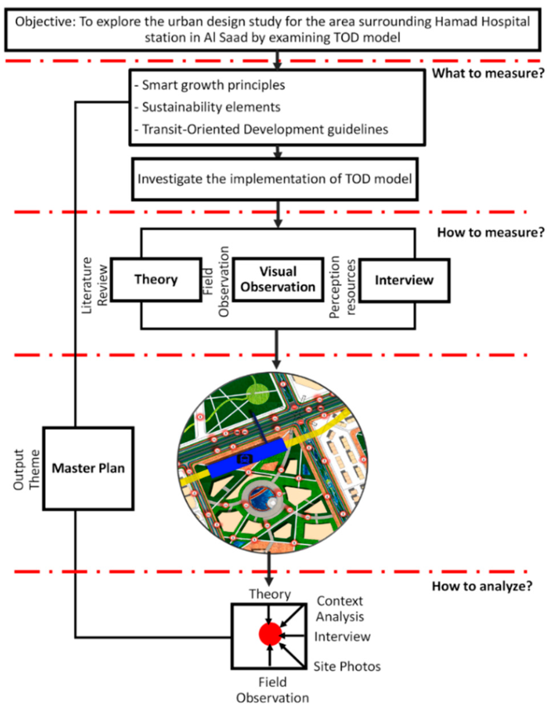
To meet the objectives of the present study, a mixed method was developed, incorporating a synthesis of qualitative and quantitative analyses through (1) a literature review focusing on sustainability, smart growth, and transit-oriented development; (2) data collection and analysis, including verbal and graphic data from Qatar Rail, the Qatari Ministry of Municipality and Environment (MME), and private engineering and consulting companies; and (3) an analytical and applied study utilizing site analysis and observation, photographs, and field notes. The research methodology of this study is depicted in Figure 6.
3.1. Literature Review
The review covered a range of literature in relevant topics including substantive sustainability theories, smart growth and TOD in international and local contexts, and ways in which the TOD model links to sustainability and smart growth. Topics more specific to the present research included issues relevant to Qatar as well as exploration of the Al Sadd study area (i.e., the area around Hamad Hospital metro station). This facilitated a synthesis of the research findings by providing evidence at a micro level, which is an essential element in setting theoretical frameworks and constructing conceptual models concerning TOD. This also helped identify key components for an implementation of TOD aimed at enhancing the study area, such as the promotion of pedestrian areas, public domains, mixed-use spaces, connectivity, walkability, and an integrated public transportation system. Finally, the review takes into account published research emphasizing the role of urban planners and designers in developing an approach to smart growth and transportation land use integration, as well as published work concerning the past, present and future growth of TODs. The theoretical framework of the research is illustrated in Figure 7.
3.2. Data Collection and Analysis
Data collection and analysis allowed a deep understanding of the study area, and incorporated oral and visual data from Qatar Rail, Qatar’s Ministry of Municipality and Environment (MME), and private engineering and consulting companies in Doha. A focus-group interview was also conducted during the first quarter of 2021 with 40 professionals working directly with TOD. These included individuals from a number of private engineering and consulting companies and government agencies, such as Jacobs Engineering Group and the Supreme Committee for Delivery and Legacy (SC), responsible for the delivery of the required infrastructure and for planning and operations for Qatar’s hosting of the 2022 FIFA World Cup.
The interviews were conducted in order to collect data about the following items: (1) current studies of the Al Sadd area and the existing land-use map; (2) an upcoming master plan for the Al Sadd area and the city of Doha, created on the initiative of the government to better sustain urban development; (3) a circulation map and the metro station’s exact location in the Al Sadd area; and (4) government plans and attempts to envision an implementation of the TOD model in the study area. Geographical information system (GIS) software—a framework for analyzing, gathering and managing data—was used to collect information on land use and the current state of the site [40]. This contributed to a better understanding of the study area through an analysis of its spatial location and other geographic data, visualized using 3D maps and images.
3.3. Analytical and Applied Study
Preliminary site visits were carried out in the investigated area at different times throughout the day and evening to build a comprehensive overview of the Al Sadd area and evaluate the site’s current condition. The site visits were appropriate for the scope of the study and allowed the determination of the types of information required for site analysis. A site survey was also conducted in the study area to obtain still more complete information concerning the Al Sadd area. These activities enabled the following: (1) building a detailed overview of currently prevailing conditions in the Al Sadd area; (2) mapping existing land uses and density of the area; (3) investigating social interfaces in the area during the daytime and evenings; and (4) determining the current use of space in the study area. In addition, photographs were taken as part of a visual examination of the current state of social interaction and the feeling of place in the Al Sadd area.
4. Findings
The results of the research paper are divided into two parts, the first of which details the analysis of the site, broken down as follows: (1) land use, (2) condition of buildings in the area, (3) density, and (4) urban fabric. The second part contains the proposed master plan and is divided as follows: (1) mixed-use spaces, community, and public spaces; (2) public realms and pedestrian-oriented neighborhoods; (3) connectivity and walkability; and (4) an integrated public transportation system.
4.1. Site Analysis
4.1.1. Land Use
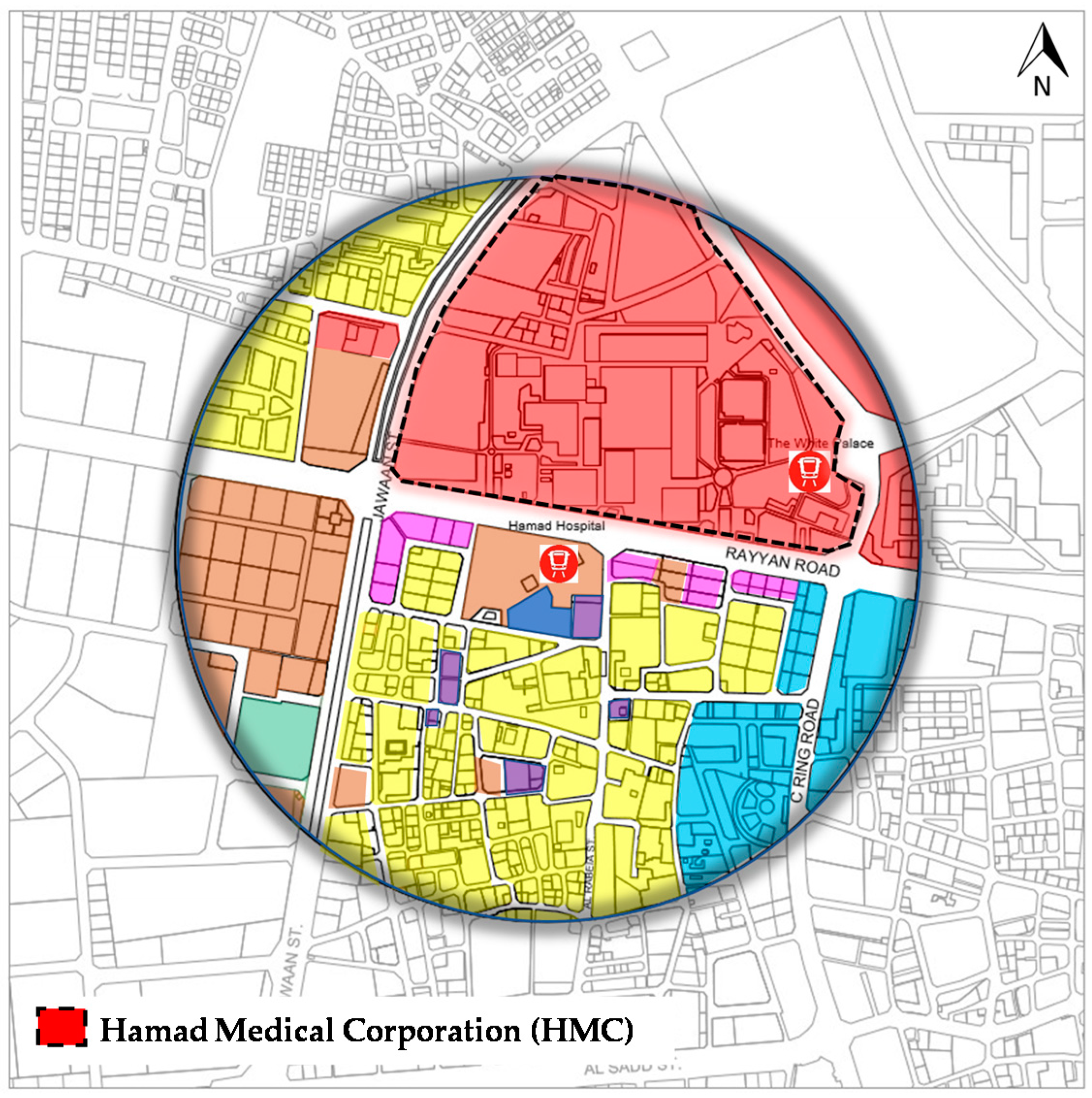
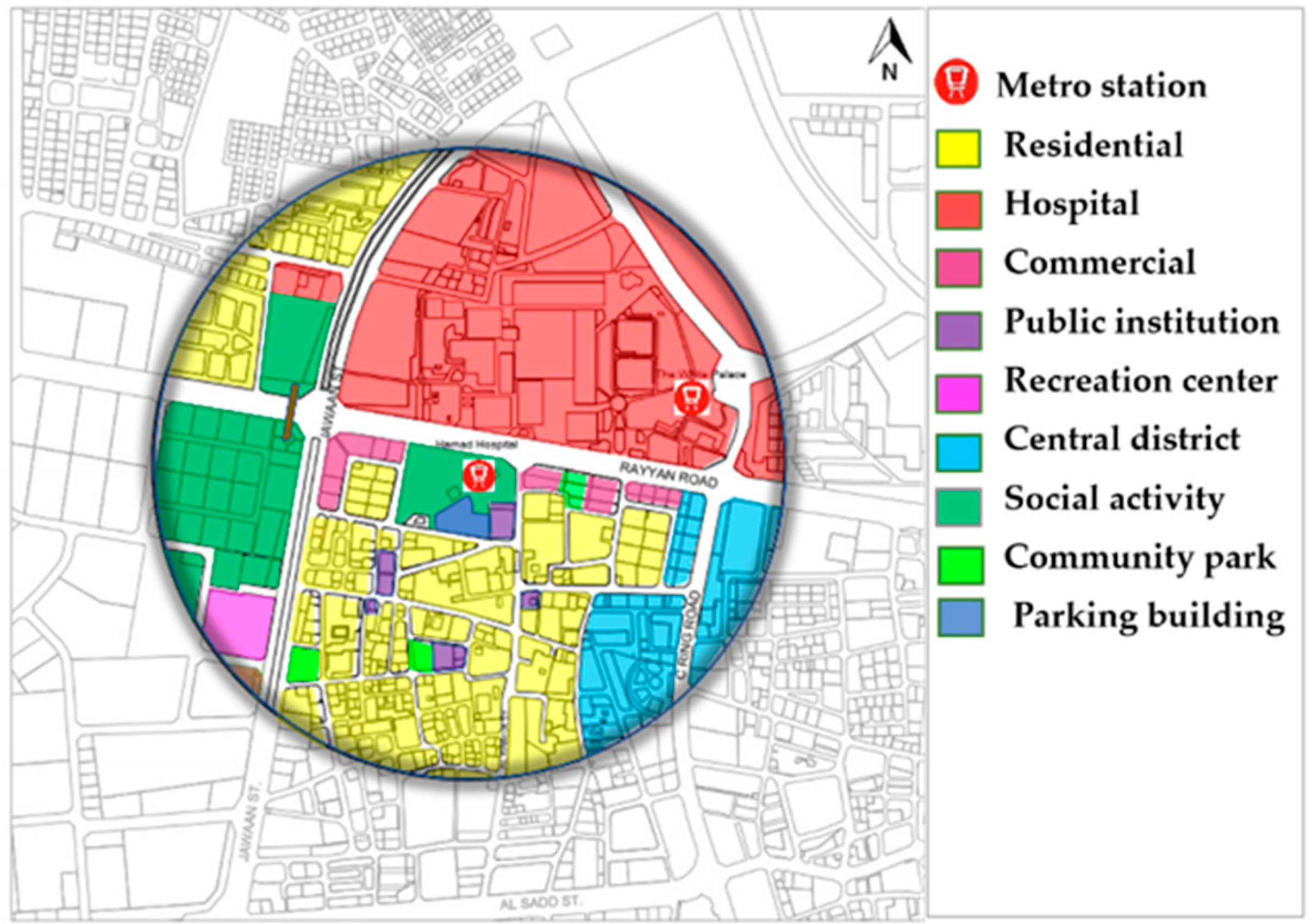
The current land use of the site is characterized by mixed-use development including residential buildings, hotels, a hospital, commercial sites, public institutions, and a recreation area. The commercial uses include shopping centers and office space, while residential uses consist of single-family and multi-family accommodations. Public institutions include Qatar Gymnastic, a municipal courthouse, and a number of schools. Throughout the site visit and observation, it was noted that the Al Sadd neighborhood generally lacks green areas and public spaces, which diminishes social inclusion and interaction. In addition, currently-existing outdoor spaces that ought to promote social interaction among individuals have generally been neglected. Some prominent features of the study area are illustrated in Figure 8 and Figure 9.
4.1.2. Condition of Buildings in the Area
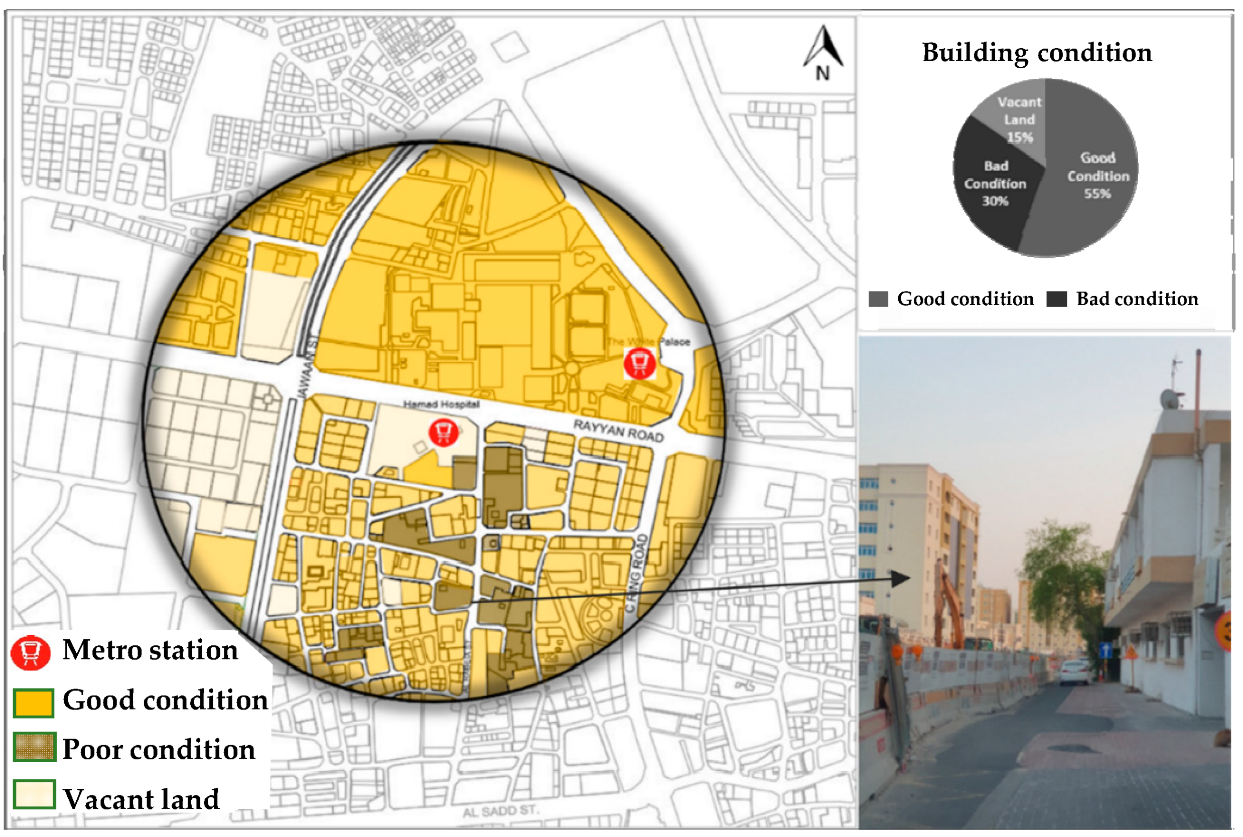
The condition of existing buildings in the study area ranges from good to poor. The determination of “good” versus “poor” is based on structural strength, extent of visible external deterioration, and overall presence or lack of maintenance. Buildings more than 30 years old were generally categorized as poor. Good buildings are fairly new structures which are structurally sound, with a clear absence of deterioration and which are visibly well maintained. As depicted in Figure 10, buildings in good condition occupy around 55% of the area, those which can be considered sub-par occupy around 30% of the area, and approximately 15% of the land is vacant.
4.1.3. Density
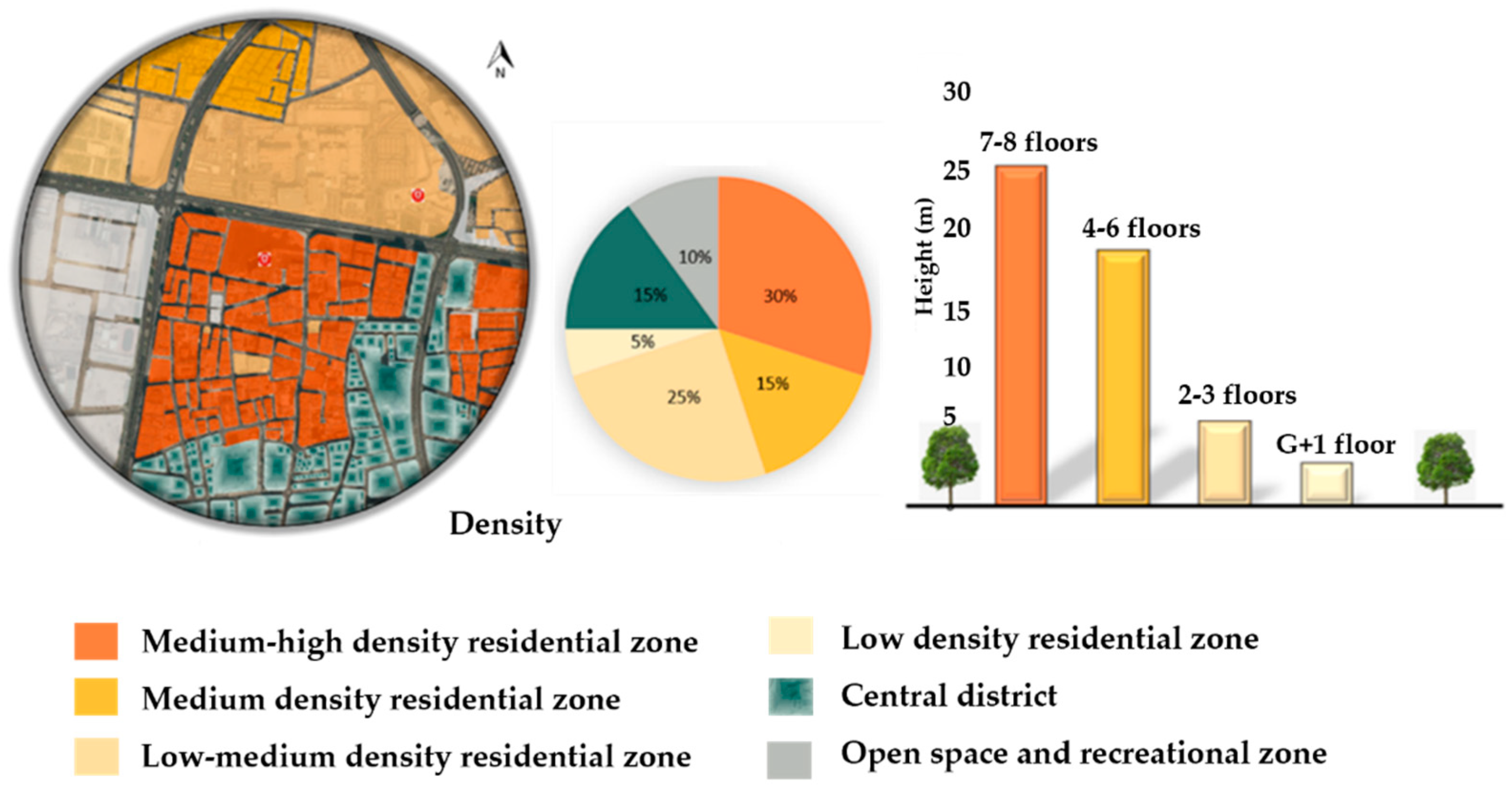
As shown in Figure 11, residential land use in the study area varies from low to medium-high density. This classification is based on the number of floors in a structure, such that medium-high density buildings have seven or eight stories, medium density structures have four to six stories, low-medium density structures have two or three stories, and low density corresponds to structures having one story. Medium-high-density residential areas cover 30% of the study zone, medium-density residential areas cover 15%, and low-medium-density residential areas cover 25%. As large residential towers are predominant in the immediate vicinity of the metro station, the highest-density part of the study area is closest to the metro station, making the station accessible to a large number of the area’s residents.
It is also important to consider the station’s accessibility for people employed in the vicinity of the station. In fact, the local business area is about 300 to 600 m from the station, which means that local employees are able to access the metro easily. The central district of Al Sadd covers 15% of the study area, open spaces and recreational areas cover 10%, and the remaining 5% is occupied by low-density residential areas. While higher density areas should ideally mean more active street life and pedestrian flow, Al Sadd currently lacks the infrastructure to facilitate stronger community interaction. Although there are pedestrian pathways, the large amount of vehicular traffic and wide (four-lane) roads in the area result in a walking experience for pedestrians that is not particularly pleasant or safe, thus minimizing the transit potential of such a high-density mixed-use area.
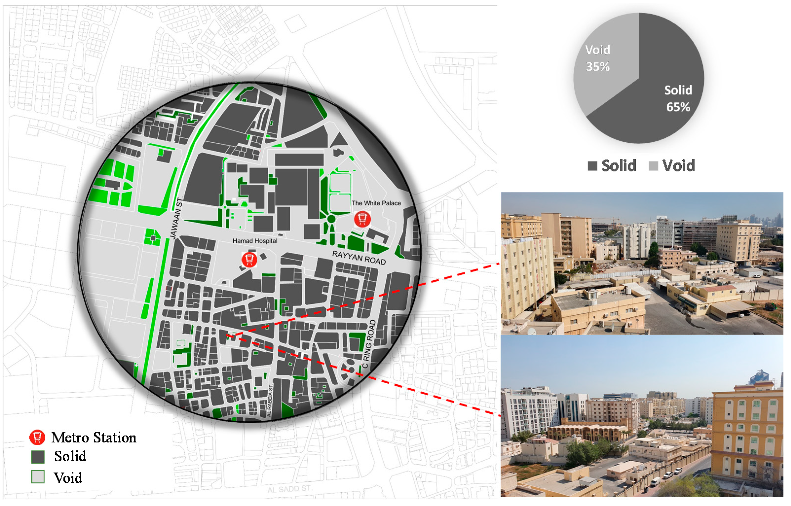
4.1.4. Urban Fabric: Solid and Void
Figure 12 illustrates the relative distribution of “solid” versus “void” areas in the study zone. It also shows that the urban fabric of the area includes both grid and organic street patterns (cf. [41]). As noted in [42], if streets are framed by tall buildings or trees in such a way that a person’s cone of vision is blocked, the area will be perceived as more “room-like” and comfortable, while fragmentation of urban form that inhibits this sense of visual enclosure will result in a perception that the area is aesthetically unappealing. Quoting directly from [42]: “By making a street more room-like, we also make it more pedestrian-friendly. People like rooms; they relate to them daily in their homes and work places, and feel comfortable and secure in them. Drivers respond to the sense of enclosure by slowing down, making the street that much more pedestrian-friendly”.
Major streets in the study area along the transit station have sporadically distributed solid and void areas. Such streets tend not to form room-like enclosures for pedestrians or vehicles, while enclosures with an ideal height-to-width ratio tend to be perceived as comfortable and safer for both. Earlier reports have stated that a minimum height-to-width ratio of 1:3 is desirable to maintain this sense of visual enclosure [42].
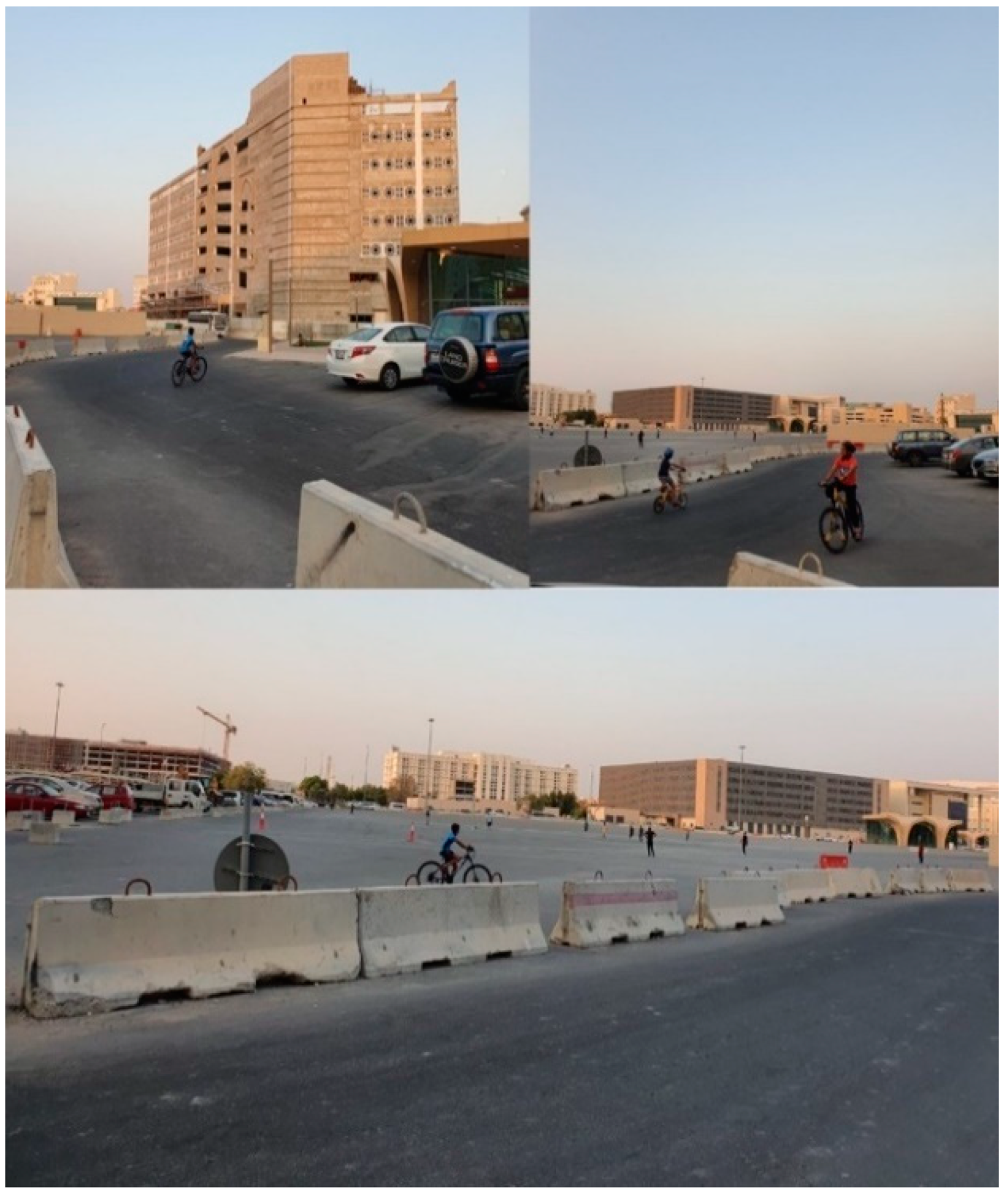
Throughout the site visit, it was noted that the study area does not elicit a clear sense of place; the result is a reduction in users’ sense of safety and in interactions among people. Furthermore, the lack of sense of space diminishes the identity of a place through which users can recognize and enjoy the uniqueness of the place. The images in Figure 13 and Figure 14 illustrate the area’s lack of spatial sense and security, the latter reflected in a general absence of integrated cycling and pedestrian paths, which also tends to diminish the quality of social life.
5. Master Plan
5.1. Mixed-Use Spaces, Community, and Public Spaces
There is a close link between TOD, social interaction, mixed uses, and the sense of place. Combined land uses with appealing and distinctive public spaces enhance the sense of space and identity in the neighborhood around a transit station. Sites with a mix of residential and commercial land uses and residential areas with a mix of recreational and commercial facilities increase opportunities for social integration and interaction. Therefore, to encourage residents to use the metro and other public transit, the study area should be mixed-use. It is also desirable to incorporate an integrated transportation system and land uses that attract new developments. Efficient and attractive infrastructure for pedestrians should also be included. The proposed master plan is illustrated in Figure 15.
5.2. Public Realms and Pedestrian-Oriented Neighborhoods
The literature review makes clear that public realms including public squares, parks, recreational centers, and souks promote community cohesiveness. Such realms also play a dynamic role in communities’ social life and enhance feelings of social inclusion. Therefore, to improve the sense of community in the study area, public spaces should include spaces for inhabitants to celebrate their cultural identity and participate in social activities. The study area should also incorporate a public realm with safe pedestrian flow adjacent to the metro station. Attractive spaces should be created which host a range of activity such as entertainment, performance and exhibits which can attract residents of all ages, genders, and cultural backgrounds, encouraging them to interact.
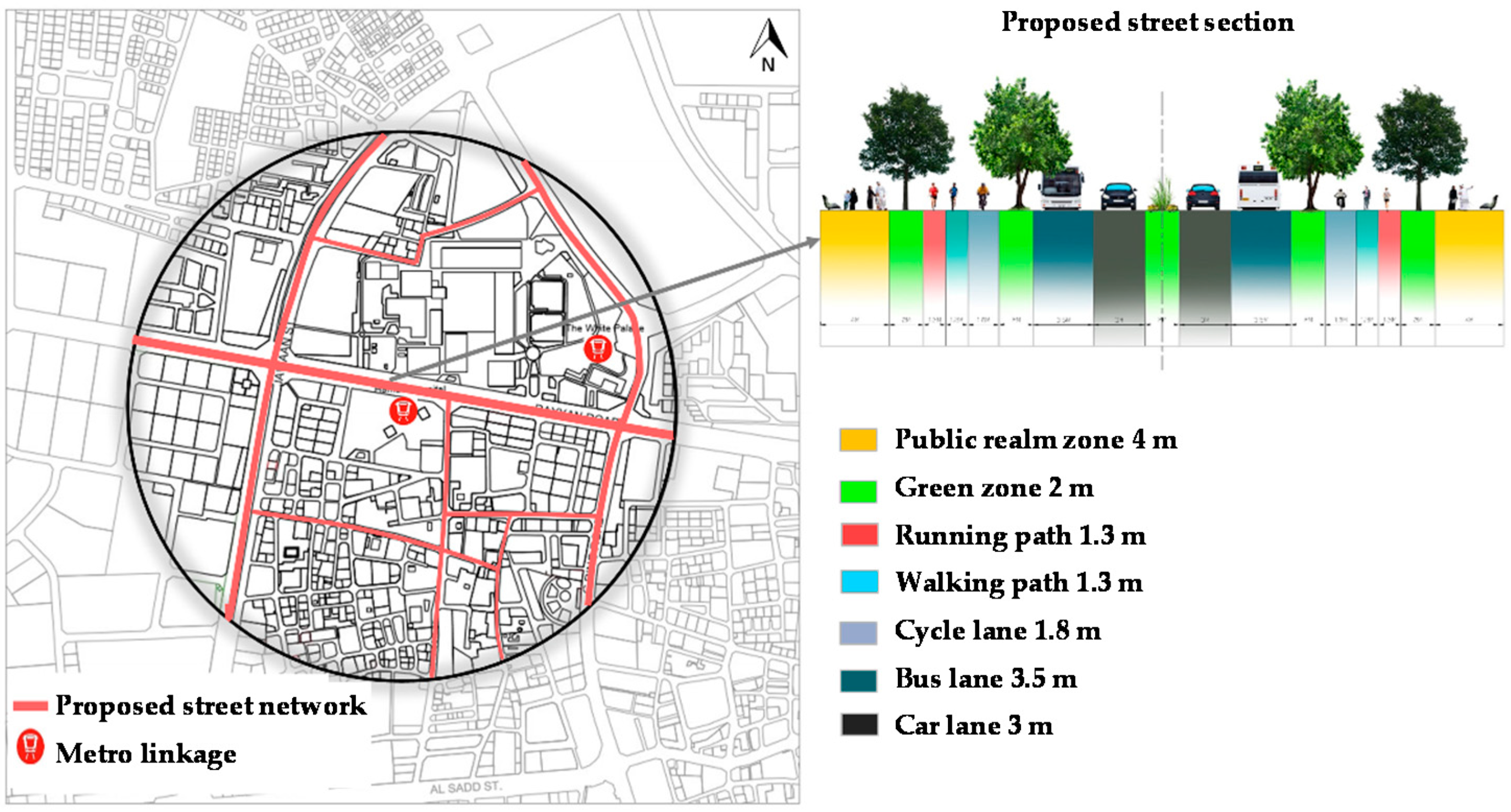
The outcome of this study is a set of recommendations for TOD implementation in the study area; these include the need to create safe and comfortable walking and cycling paths, as well as improving the pedestrian experience by implementing a place-making approach. In order to promote a pedestrian-oriented neighborhood, the study area needs to provide traffic-calming measures and vehicle-free paths, in addition to including temperature-moderating techniques such as misting machines and paths with shading systems and trees. The cross-section was designed based on the Qatar highway design manual [43]. This part of the proposal is illustrated in Figure 16.
5.3. Connectivity and Walkability
To facilitate the creation of TOD in the study area, an analysis of the deficiencies in connectivity to and from the metro station was performed. To mitigate these, the following guidelines should be established: (1) connecting cycling and pedestrian paths and including traffic calming measures, vehicle-free lanes, and shading techniques at key locations; (2) providing better linkage to and from the neighborhood by connecting cycling routes to adjacent networks; (3) linking public areas and parks at street level through the thoughtful use of pedestrian and bicycle routes; (4) incorporating diverse transportation options that facilitate people’s connection to homes, schools, health centers, workplaces and parks; and (5) providing reliable and accessible transportation options within walking distance for all residents.
5.4. Integrated Public Transportation System
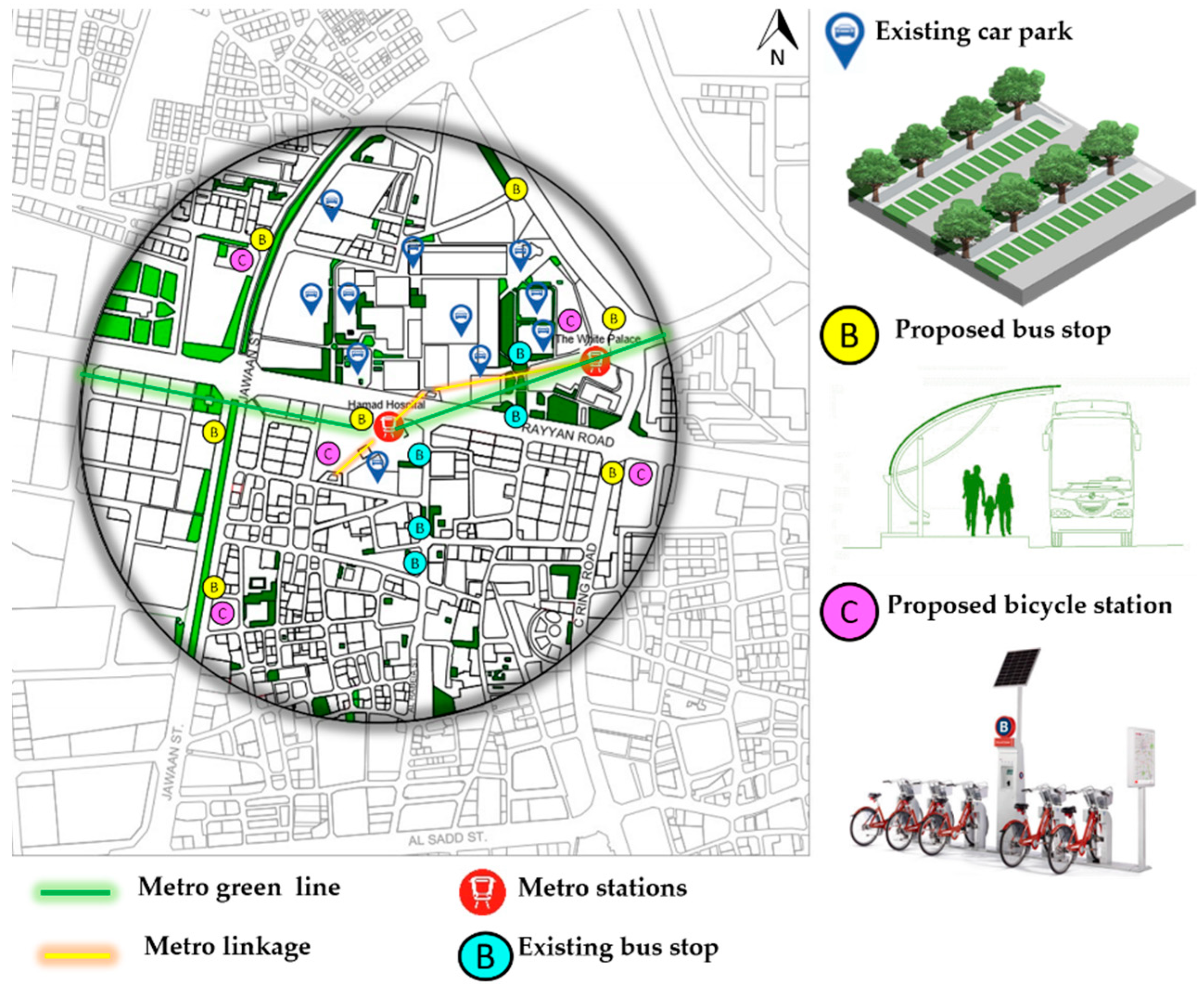
An integrated transportation system in the study area needs to be developed in order to enhance mobility; promote public transport; and allow optimal usage of land near rail stations, bus stops and transport corridors. Access to metro stations, bus routes, and other public transport services should be improved, and safe access to public transport facilities by cyclists and pedestrians should be ensured. In particular, shading areas along walkways and raised pedestrian crossings should be provided on the roads adjacent to the station in order to ensure safe and comfortable pedestrian access.
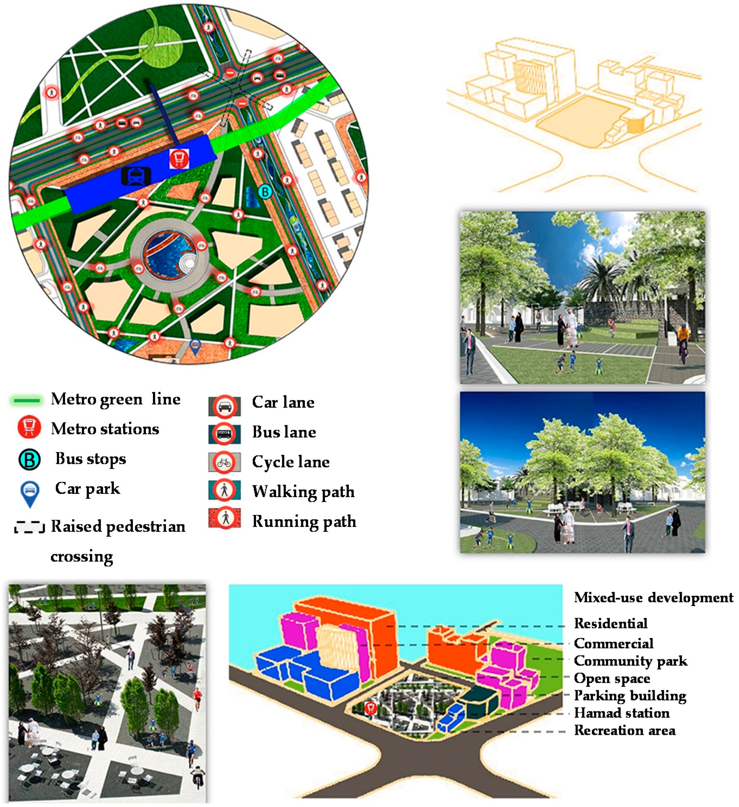
By implementing these recommendations, a number of benefits will accrue to the study area and its users, including (1) enhanced access to services, retail outlets, and recreational centers; (2) expanded mobility options and better access to the public transport network; (3) reduced traffic congestion; (4) better air quality and reduced gasoline consumption; (5) greater ability to access public spaces, parks, and squares. A schematic of the master plan, incorporating a 3D model, is illustrated in Figure 17.
6. Discussion and Conclusions
The concept of transit-oriented development (TOD) has sparked growing interest in an increasing number of communities during the past two decades, as an integral part of a cohesive approach toward transportation and land use, one which promotes a mixed-use and compact urban fabric with well-implemented public transport, in turn supporting sustainable urban growth.
The present research project investigated an implementation of the TOD model for the area surrounding Hamad Hospital metro station in Doha’s Al Sadd neighborhood; the investigated area was defined as the region located within an 800-m radius around this metro station. The result was a plan for improving the urban fabric of the study area through a set of design proposals and guidelines to implement a TOD model in that area. This is achieved in large part by establishing a place-making approach promoting pedestrian- and cycling-oriented neighborhoods, by means of the following: (1) including appropriate and adequate walking and cycling spaces by creating connected walking and cycling paths; (2) introducing traffic-calming measures and creating vehicle-free paths; (3) creating cool shaded footpaths with trees and other shading systems; (4) enhancing a mixed land use approach incorporating attractive public spaces; and (5) establishing a unique identity and sense of place around the station area. Some of these ideas are illustrated in Figure 18.
The findings of this study highlight the importance of TOD for the urban form of Qatar in the country’s efforts to improve living conditions in its emerging urban transit villages. The development of the Doha metro system offers a rare opportunity to adopt a wide-ranging approach to the urban renewal of the city’s transit communities and for improving the city’s livability. TOD is an essential tool for planning transport systems, and can aid urban planners seeking to attract users to Doha’s metro and other public transport options, reducing the population’s heavy dependence on private automobiles and thus easing traffic congestion. The TOD model for this study’s target site can help promote efficiency and livability in the neighborhood’s land-use patterns and transportation system, consequently forming a pedestrian-friendly and sustainable neighborhood in harmony with Qatar National Vision 2030 and with the theory reviewed in the literature review. Smart growth, when implemented in line with TOD strategies, creates walkable and friendly environments that promote physical activity and enhance compact growth forms with land-use variety, pedestrian-oriented design, and higher densities which lessen the need for automobile use for short trips.
Finally, in order to encourage the use of the metro and other public transport options, the proposed master plan for the study area includes mixed-use compact spaces serving as commercial, residential, recreational and/or integrated activity areas that are all enhanced via the inclusion of convenient walkways and clearly marked streets. The master plan also incorporates an integrated transportation system and land use, including an efficient and pleasant pedestrian network, which can attract new development, thus enhancing users’ opportunities and leading to an overall better way of life in the city.
7. Contribution to Knowledge
The implementation of TOD can be greatly beneficial to the city of Doha, as it is currently facing increased urban sprawl. The TOD model favors the development of multiple movement options within a community, with an emphasis on sustainability. TOD thus favors the creation of pedestrian- and cyclist-safe pathways and mass transit facilities, while permitting auto access where needed; this leads naturally to increased use of the public transport system and reduces vehicle miles traveled (VMT). As a result, the TOD design strategy is also valuable in that it reduces driving costs and increases net incomes, in addition to reducing energy usage and air pollution. Other benefits include conservation of lands and open spaces, increased supply of affordable housing and overall economic development, and reduction in expenditures needed for infrastructure.
While current TOD principles have helped Western cities reinterpret the concept for local implementation, examples of their successful implementation in non-Western contexts are few. Therefore, the urban fabric, identity, and heritage of non-Western cities (such as those in the Gulf region) should be considered when planners and architects define a TOD model, because such a model cannot be applied as a universal with no reference to place-making. The present study is thus tailored to a specific urban area of Doha and provides input to urban planners, scholars and architects for better shaping TODs in Doha while still respecting the city’s vernacular urban fabric. This study incorporates common TOD goals as well as principles recognizing identity and heritage as related to the place-making approach. By encouraging high-quality station architecture and a public realm that is sensitive to the surrounding built context while providing basic amenities, a comfortable and smooth user experience can be ensured.
The establishment of TOD as a practical way to promote smart growth can be of great benefit for Qatar’s future development in alignment with Qatar National Vision 2030. Well-integrated transit cores will enhance the urban form of Qatar’s metropolitan areas. More generally, TOD planning is invaluable for cities aiming to promote a variety of sustainable mobility modes such as pedestrian and bicycle travel, while still permitting automobile access where needed. This leads to an increase in the proportion of a city’s users using public transport while simultaneously reducing vehicle miles traveled (VMT) within that city. Implementing TOD will expand investment opportunities and enhance urban livability in ways that will open opportunities to better housing choices, a greater variety of urban lifestyles, and unique centers of activity.
8. Implications for Practice and Advancement of Research
The transit-oriented approach to urban growth is an important means of promoting compact development patterns supported by high-quality transport schemes improving urban mobility. TOD also improves wealth-building as well as creating better opportunities for residents, allowing communities to be more flexible in addressing future disruptive events such as pandemics. TOD reduces air pollution and improves affordability and sustainability by promoting neighborhood diversity, walkability, and compact development close to transit hubs.
Smart growth and urban sustainability are thus increasingly crucial as cities seek to resolve the challenges they face in the 21st century. There is also a need to adapt and share findings and tools in a user-friendly inclusive suite of TOD-related guides, tools, and resources, particularly in overcoming challenges of TOD execution in developing cities.
The paper proposes a well-planned TOD which addresses the urban needs of the State of Qatar by (1) integrating development with transportation, and (2) incorporating mixed-use, high-density development which will act to generate sustainable and livable urban communities in which users can cycle or walk to public transport facilities connecting to more distant locations. This research can offer significant insights for implementing TOD strategies in numerous parts of the urban strategy establishment. Future research could consider well-planned and effective implementation of TOD to promote sustainable and livable cities in other locations.
Author Contributions
The authors contributed to this research study as follows: conceptualization, S.N., R.F., M.G.; methodology, S.N., R.F., M.G.; software, S.N., K.L.M.; validation, S.N., R.F., M.G., R.A.-M.; formal analysis, S.N., R.F., M.G., R.A.-M.; investigation, S.N., R.F., M.G., R.A.-M., K.L.M.; resources, R.F., M.G., R.A.-M.; data curation, S.N., K.L.M.; writing—original draft, S.N., R.F.; preparation, S.N., R.F., M.G., R.A.-M., K.L.M.; writing—review and editing, R.F., M.G.; visualization, S.N., K.L.M., supervision, R.F., R.A.-M.; project administration, R.F., R.A.-M.; funding acquisition, R.F., R.A.-M. All authors have read and agreed to the published version of the manuscript.
Funding
This research study was developed under the grant schemes awarded by (i) Qatar National research Fund [QNRF] a member of Qatar Foundation: Grant ID: GSRA7-1-0502-20030; and (ii) Qatar University [QU]: Grant ID: QUCP-CENG-2021-2 [NATIONAL CAPACITY BUILDING PROGRAM-NCB-S1], titled: Re-thinking a Framework for the Urban Regeneration and Preservation of the Transit Villages of Old Salata, QNM, Msheireb and Souq Waqif. English editing, proof-reading, and article processing charge (APC) were fully supported by Qatar University, under Grant ID: QUCP-CENG-2021-2 [NATIONAL CAPACITY BUILDING PROGRAM-NCB-S1].
Institutional Review Board Statement
Not applicable.
Informed Consent Statement
Not applicable.
Data Availability Statement
All data, models, and code generated or used during the study appear in the submitted article.
Acknowledgments
The authors would like to acknowledge the support of Qatar University in providing a work environment which facilitates and motivates scientific research. This research study was developed as a part of the core course “Participatory Design and Planning” in Fall 2020, part of the PhD program in Architecture at Qatar University. The authors would like to thank the leading engineers and key professional people working in governmental agencies and municipalities in Qatar, specifically those in the Ministry of Municipality and Environment (MME), the Ministry of Transport and Communications (MOTC), Qatar Rail, Mowasalat, and the Ashghal Public Works Authority. Their cooperation and collaboration with the authors were crucial in the development of this research study. This included meetings; the provision of visual materials, guidelines and frameworks; and discussion of future plans. Finally, the authors would like to thank the reviewers and editors for their invaluable feedback. The authors are solely responsible for the statements made herein.
Conflicts of Interest
The authors declare no conflict of interest.
References
- Reconnecting America. Station Area Planning: How to Make Great Transit-Oriented Places. Available online: http://reconnectingamerica.org/assets/Uploads/tod202.pdf. (accessed on 20 April 2021).
- Calthorpe, P. The Next American Metropolis: Ecology, Community, and the American Dream; Princeton Architectural Press: New York, NY, USA, 1993; Volume 1, p. 175. [Google Scholar]
- Renee, R.A. Sustainable development in Qatar: Challenges and opportunities. QScience Connect. 2014, 2014. [Google Scholar] [CrossRef]
- Al-Harami, A.; Furlan, R. Qatar National Museum-Transit oriented development: The masterplan for the urban regeneration of a ‘green TOD’. J. Urban Manag. 2020, 9, 115–136. [Google Scholar] [CrossRef]
- Alattar, D.A.; Furlan, R. Urban Regeneration in Qatar: A Comprehensive Planning Strategy for the Transport Oriented Development (TOD) of Al-Waab. J. Urban Regen. Renew. 2017, 11, 168–193. [Google Scholar]
- Wey, W.-M. Smart growth and transit-oriented development planning in site selection for a new metro transit station in Taipei, Taiwan. Habitat Int. 2015, 47, 158–168. [Google Scholar] [CrossRef]
- Gehrke, S.R.; Clifton, K.J. A pathway linking smart growth neighborhoods to home-based pedestrian travel. Travel Behav. Soc. 2017, 7, 52–62. [Google Scholar] [CrossRef] [Green Version]
- Appleyard, B.S.; Frost, A.R.; Allen, C. Are all transit stations equal and equitable? Calculating sustainability, livability, health, & equity performance of smart growth & transit-oriented-development (TOD). J. Transp. Health 2019, 14, 100584. [Google Scholar]
- Mai, X.; Zhan, C.; Chan, R.C.K. The nexus between (re)production of space and economic resilience: An analysis of Chinese cities. Habitat Int. 2021, 109, 102326. [Google Scholar] [CrossRef]
- Knowles, R.D.; Ferbrache, F.; Nikitasc, A. Transport’s historical, contemporary and future role in shaping urban development: Re-evaluating transit oriented development. Cities 2020, 99, 102607. [Google Scholar] [CrossRef]
- Furlan, R.; Petruccioli, A.; David Major, M.; Zaina, S.; Zaina, S.; Al Saeed, M.; Saleh, D. The urban regeneration of west-bay, business district of Doha (State of Qatar): A transit-oriented development enhancing livability. J. Urban Manag. 2019, 8, 126–144. [Google Scholar] [CrossRef]
- Furlan, R.; Zaina, S.; Patel, S. The urban regeneration’s framework for transit villages in Qatar: The case of Al Sadd in Doha. Environ. Dev. Sustain. 2021, 23, 5920–5936. [Google Scholar] [CrossRef]
- Ewing, R.H. Pedestrian- and Transit-Friendly Design: A Primer for Smart Growth; Smart Growth Network: Washington, DC, USA, 1999. [Google Scholar]
- Dittmar, H.; Ohland, G. The New Transit Town: Best practices in Transit-Oriented Development; Island Press: Washington, DC, USA, 2012. [Google Scholar]
- Carlton, I. Histories of Transit-Oriented Development: Perspectives on the Development of the TOD; Institute of Urban and Regional Development, University of California: Berkeley, CA, USA, 2009. [Google Scholar]
- Lamour, Q.; Morelli, A.M.; Marins, K.R.D.C. Improving walkability in a TOD context: Spatial strategies that enhance walking in the Belém neighbourhood, in São Paulo, Brazil. Case Stud. Transp. Policy 2019, 7, 280–292. [Google Scholar] [CrossRef]
- Joshi, D. Transit-Oriented Development Handbook; Planning Executive Advisory Committee (PEAC): Winnipeg, MB, Canada, 2011. [Google Scholar]
- Marthya, K.; Furlan, R.; Ellath, L.; Esmat, M.; Al-Matwi, R. Place-Making of Transit Towns in Qatar: The Case of Qatar National Museum-Souq Waqif Corridor. Designs 2021, 5, 18. [Google Scholar] [CrossRef]
- Pal, S. Measuring Transit Oriented Development of Existing Urban Areas around Metro Stations in Faridabad City. Int. J. Built Environ. Sustain. 2018, 5, 115–126. [Google Scholar] [CrossRef] [Green Version]
- Franco Trujillo, D. Pursuing Sustainable Transport through Spatial Planning: A case study of the Stuttgart Region. Master’s Thesis, University of Stuttgart, Stuttgart, Germany, 2016. [Google Scholar]
- Renaissance, P. Achieving Outcomes for TOD: An Analysis of Readiness User Guide and Documentation. Available online: https://planfortransit.com/wp-content/uploads/2016/01/Station-Area-TOD-Readiness-Tool-User-Guide.pdf (accessed on 30 March 2021).
- Alwehab, A.; Abdul Ghafoor Al Ani, M. Urban Optimization of Transit Oriented Development in Baghdad City. Civ. Environ. Res. 2016, 8, 38–47. [Google Scholar]
- Loo, B.P.Y.; Chen, C.; Chan, E. Rail-based transit-oriented development: Lessons from New York City and Hong Kong. Landsc. Urban Plan. 2010, 97, 202–212. [Google Scholar] [CrossRef]
- Andersen, M.C. Women and Cycling: Lille Study Case (France), in Copenhagenize. 2013. Available online: https://copenhagenize.eu/news-archive/2021/2/8/women-amp-cycling-lille-study-case-france (accessed on 10 March 2021).
- Ann, S.; Jiang, M.; Yamamoto, T. Re-examination of the standards for transit oriented development influence zones in India. J. Transp. Land Use 2019, 12, 679–700. [Google Scholar] [CrossRef]
- Board, T.R.; National Academies of Sciences, Engineering, and Medicine. Transit-Oriented Development in the United States: Experiences, Challenges, and Prospects; Transportation Research Board: Washington, DC, USA, 2004; Volume 102. [Google Scholar] [CrossRef]
- Heba, O.; Tannous, R.F.; Major, M.D. Souq Waqif Neighborhood as a Transit-Oriented Development. J. Urban Plan. Dev. 2020, 146. [Google Scholar] [CrossRef]
- Burt, J.A.; Ben-Hamadou, R.; Abdel-Moati, M.A.R.; Fanning, L.; Kaitibie, S.; Al-Jamali, F.; Range, P.; Saeed, S.; Warren, C.S. Improving management of future coastal development in Qatar through ecosystem-based management approaches. Ocean Coast. Manag. 2017, 148, 171–181. [Google Scholar]
- Wiedmann, F.; Mirincheva, V.; Salama, A.M. Urban Reconfiguration and Revitalisation: Public Mega Projects in Doha’s Historic Centre. Open House Int. 2013, 38, 27–36. [Google Scholar] [CrossRef]
- Zaidan, E.; Abulibdeh, A. Modeling ground access mode choice behavior for Hamad International Airport in the 2022 FIFA World Cup city, Doha, Qatar. J. Air Transp. Manag. 2018, 73, 32–45. [Google Scholar] [CrossRef]
- Nafi, S.I.; Alattar, D.A.; Furlan, R. Built form of the Souq Waqif in Doha and user’s social engagement. Am. J. Sociol. Res. 2015, 5, 73–88. [Google Scholar]
- Boussaa, D.; Alattar, D.; Nafi, S. The search for identity in a global world: The case of Doha in Qatar. J. Urban Regen. Renew. 2021, 14, 295–311. [Google Scholar]
- Rizzo, A. Rapid urban development and national master planning in Arab Gulf countries. Qatar as a case study. Cities 2014, 39, 50–57. [Google Scholar]
- Mannan, M.; Alhaj, M.; Mabrouk, A.N.; Al-Ghamdi, S.G. Examining the life-cycle environmental impacts of desalination: A case study in the State of Qatar. Desalination 2019, 452, 238–246. [Google Scholar] [CrossRef]
- Al-Janahi, S.A.; Ellabban, O.; Al-Ghamdi, S.G. Technoeconomic feasibility study of grid-connected building-integrated photovoltaics system for clean electrification: A case study of Doha metro. Energy Rep. 2020, 6, 407–414. [Google Scholar] [CrossRef]
- Fort, J.R.; Diaz, J.A.; Catalina, S.C.; Boudet, J.M.C.; Herrero, M.P. Red Line South. Metro de Doha (Qatar). Estructuras singulares construidas in-situ de ancho o canto variable. Hormigón Y Acero 2017, 68, 129–138. [Google Scholar]
- Amerio, M. Doha Metro Project: 3TI lesson learned. Transp. Res. Procedia 2020, 45, 866–873. [Google Scholar] [CrossRef]
- AlKhereibi, A.; AlSuwaidi, M.; Al-Mohammed, R.; Pokharel, S.; Ayari, M. An integrated urban-transport smart growth model around metro stations: A case of Qatar. Transp. Res. Interdiscip. Perspect. 2021, 10, 100392. [Google Scholar]
- Al-Thawadi, F.E.; Banawi, A.-A.A.; Al-Ghamdi, S.G. Social impact assessment towards sustainable urban mobility in Qatar: Understanding behavioral change triggers. Transp. Res. Interdiscip. Perspect. 2021, 9, 100295. [Google Scholar]
- Saadallah Raheem, F. Application of software in the development of advanced database systems for the management of transport in the city of Baghdad using GIS. Mater. Today Proc. 2021. [Google Scholar] [CrossRef]
- Tapsuwan, S.; Mathot, C.; Walker, I.; Barnett, G. Preferences for sustainable, liveable and resilient neighbourhoods and homes: A case of Canberra, Australia. Sustain. Cities Soc. 2018, 37, 133–145. [Google Scholar] [CrossRef]
- Furlan, R.; Almohannadi, M. Light rail transit and land use in Qatar: An integrated planning strategy for Al-Qassar’s TOD. Int. J. Archit. Res. ArchNet-IJAR 2016, 10, 170–192. [Google Scholar] [CrossRef]
- Ministry of Municipality and Environment, Qatar Highway Design Manual. 2014. Available online: http://www.mme.gov.qa/cui/view.dox?id=1369&contentID=2766&siteID=2. (accessed on 20 April 2021).
Figure 1.
Illustration of transit-oriented development (TOD).

Figure 2.
TOD compact nodes linked by mass transit.

Figure 3.
How cities should be designed.

Figure 4.
Four typical density distributions.

Figure 5.
Location maps showing the Al Sadd area and Hamad Hospital metro station within Doha.

Figure 6.
Illustration of the research methodology.

Figure 7.
Representation of the theoretical framework of the research.

Figure 8.
Existing land-use map.

Figure 9.
Location of Hamad Medical Corporation.

Figure 10.
Building conditions in the study area.

Figure 11.
Land use density map and typical building heights.

Figure 12.
Solid and void map.

Figure 13.
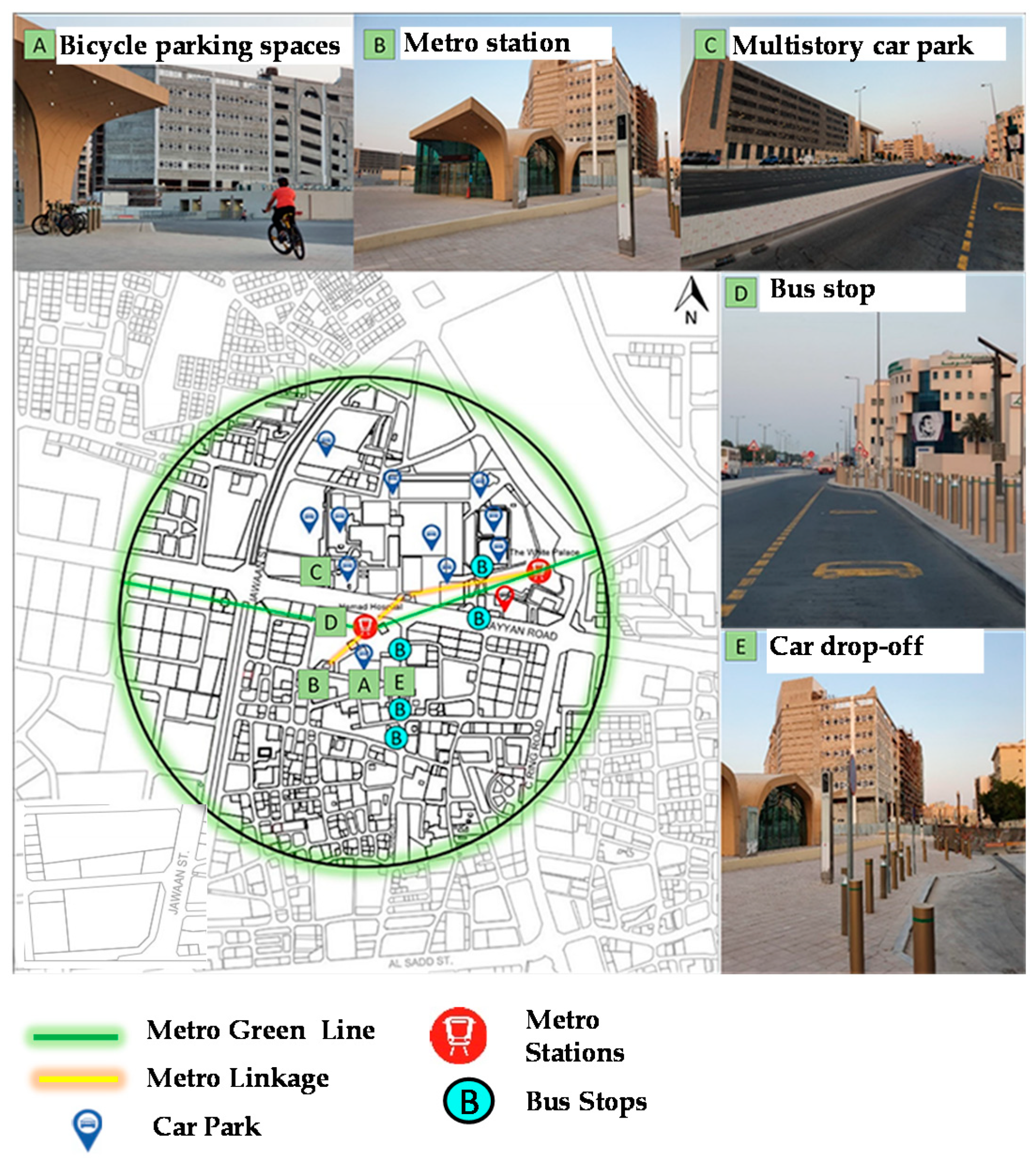
Transportation map.

Figure 14.
Illustration of the lack of sense of place and safety in the Al Saad area.

Figure 15.
Proposed master plan.

Figure 16.
Proposed public transportation network.

Figure 17.
Master plan and 3D proposal.

Figure 18.
Proposed inter-mobility and transportation hubs.

Publisher’s Note: MDPI stays neutral with regard to jurisdictional claims in published maps and institutional affiliations. |
© 2021 by the authors. Licensee MDPI, Basel, Switzerland. This article is an open access article distributed under the terms and conditions of the Creative Commons Attribution (CC BY) license (https://creativecommons.org/licenses/by/4.0/).
Share and Cite
MDPI and ACS Style
Nafi, S.; Furlan, R.; Grosvald, M.; Al-Matwi, R.; Lifam Marthya, K. Transit-Oriented Development in Doha: The Case of the Al Sadd Neighborhood and Hamad Hospital Metro Station. Designs 2021, 5, 61. https://doi.org/10.3390/designs5040061
AMA Style
Nafi S, Furlan R, Grosvald M, Al-Matwi R, Lifam Marthya K. Transit-Oriented Development in Doha: The Case of the Al Sadd Neighborhood and Hamad Hospital Metro Station. Designs. 2021; 5(4):61. https://doi.org/10.3390/designs5040061
Chicago/Turabian StyleNafi, Sara, Raffaello Furlan, Michael Grosvald, Rashid Al-Matwi, and Khalida Lifam Marthya. 2021. "Transit-Oriented Development in Doha: The Case of the Al Sadd Neighborhood and Hamad Hospital Metro Station" Designs 5, no. 4: 61. https://doi.org/10.3390/designs5040061